The Lasting Legacy of the Deepwater Horizon Oil Spill

By Delaney Reynolds, SRC intern

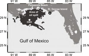
This map of how far the oil reached on the surface level of the Gulf of Mexico exhibits that the coasts of Texas, Louisiana, Mississippi, Alabama, and Florida were impacted.
(Source: Huettel, M., Overholt, W. A., Kostka, J. E., Hagan, C., Kaba, J., Wells, B., & Dudley, S. (2017, December 22). Degradation of Deepwater Horizon oil buried in a Florida beach influenced by tidal pumping. Retrieved March 13, 2018, from https://www.sciencedirect.com/science/article/ pii/S0025326X1730903)

Mankind’s use of fossil fuels as an energy source can place our natural environment at grave risk, and nowhere is that more acute than in the Gulf of Mexico. The environmental threats the Gulf region faces from petroleum production and exploration are not just those that appear in the media immediately following an oil spill or similar catastrophe, but are events that leave a lasting, often unseen legacy that stands to pollute and destroy our natural environment and the creatures that live in it for generations.

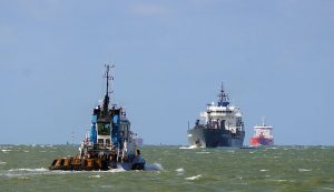
The Deepwater Horizon, British Petroleum (BP), oil spill of 2010 was the largest marine oil spill in history and polluted the Gulf for 87 days by pouring an estimated 60,000 barrels per day at its peak, and over 3.19 million barrels in total, of petroleum into the Gulf’s environment (Pallardy). The oil’s effluence rapidly spread to over 1,000 miles on the coastlines of Texas, Louisiana, Mississippi, Alabama, and Florida and while the efforts to clean up beaches and the spill itself have had some success, remnants of oil remain buried in sediments and continue to dramatically disrupt life beneath the surface (Frost).

Florida State University researchers discovered that within a week of burial, two thirds of the oil that washed ashore was retained in coastal sediments and caused a decrease in biodiversity by over 50% (Huettel). Bacterial abundance increased drastically in heavily oiled sands as the bacteria thrived off the oil and, thus, caused bacteria blooms, lowering overall oxygen content. This decrease in oxygen content, in turn, caused the decrease of biodiversity as aerobic organisms either perished or migrated to areas with a higher oxygen content. However, within three months, a resurgence in microorganisms normalized biodiversity as they restocked the coastal waters with the oxygen that aerobic organisms’ survival necessitates. Not only does this exemplify the ability of aquatic ecosystems to replenish themselves after being exposed to stressors, but it also supplies us with knowledge of the types of microorganisms that could be utilized to clean up future spills, as well as any environmental impacts they may cause to other organisms.

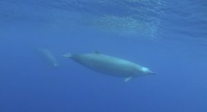
One example of a lasting major environmental impact of the spill to other species from exposure to crude oil is pelagic fish cardiac and swim performance impairment which, in turn, has been found to lead to the inability of embryonic development. Mahi-mahi embryos obtained from the University of Miami Experimental Hatchery and yellow fin tuna embryos obtained from the Inter-American Tropical Tuna Commission’s Achotines Laboratory were collected as experimental specimen and exposed to different dilutions of crude oil collected from the Deepwater Horizon Oil Spill site, as well as varying levels of ultraviolet radiation (UV) exposure, for 96 hours in a pelagic embryo-larval exposure chamber (PELEC). Mahi-mahi specimens exposed to higher levels of UV radiation were found to have a nine-fold increase in toxicity from Deepwater Horizon crude oil increasing stress levels within the fish. Yellow fin tuna survival rates were found to be significantly higher in the PELEC system than in the agitated system, meaning their survival rate decreased by a measure of 20% when exposed to crude oil and UV radiation (Steiglitz). Events such as the Deepwater Horizon oil spill can challenge pelagic fish, especially embryos and their ability to develop correctly and survive. Thus, this research provides ways in which we can begin to predict the extreme environmental conditions species would face in future oil spills, as well as examine how remnants of oil preserved in sediments may affect spawning grounds among certain species.

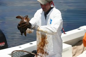
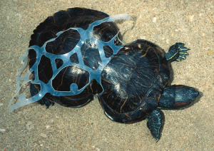
Kemp’s Ridley sea turtle (Lepidochelys kempii) covered in crude oil
(Source: http://www.noaanews.noaa.gov/stories2015/ 20150504-noaa-announces-new-deepwater-horizon-oil-spill-searchable-database-web-tool.html).

Another example of the diverse and devastating impact that an oil spill can have can be found in northwest Florida, where the loggerhead turtle (Caretta caretta) has been found to have varying offspring densities in nests since the Deepwater Horizon spill in 2010. Using a before-after, control-impact statistical model, researchers from the US Fish and Wildlife Service and Florida Fish and Wildlife Conservation Commission examined the historical records of loggerhead turtle nest densities and compared them to nest densities after 2010. They found that loggerhead nest densities in 2010 were reduced by 43.7% following the Deepwater Horizon oil spill and approximately 251 nests were decimated by crude oil and cleanup efforts, having a long-term impact on population sizes (Lauritsen). The drastic decline is due in part to the oil that entered “nearshore areas and washed onto beaches along the northern Gulf of Mexico shoreline during the summer of 2010, requiring extensive, disruptive activities to remove contaminated beach sand, oil, and debris” (Lauritsen). Nesting densities increased to normal rates in 2011 and 2012 suggesting some loggerhead sea turtles avoided mortality from oil saturation. Researchers later estimated that at least 65,000 sea turtles perished in 2010, likely exacerbated by oil contamination (Pallardy).

There are few places on earth as lovely and naturally beautiful as the Gulf of Mexico. From its sandy white beaches, coastal marshes and abundant estuaries, to its serene salt waters, the Gulf region is a critical environment that humans and countless animal species rely upon for food, shelter, and recreation. Sadly, since 2010 when the Deepwater Horizon spill event took place, there have been at least 234 additional oil spills here in the United States as of December 2017 (ITOPF). And while the immediate impact of a spill is unacceptable, the lasting legacy such as sediments that retain oil particles long after a spill occurs and its impact on range of species across the food chain from microorganisms to sea turtles to mahi-mahi and yellow fin tuna should concern all of us. As populations continue to grow, so too will energy needs and this, along with the constant threat from yet another oil spill and the long-term implications its pollution has on our environment, makes managing these risks, while also embracing and evolving to sustainable energy solutions, critical to nature and humans alike.

Works Cited

Frost, E. (2018, February 28). Gulf Oil Spill. Retrieved March 15, 2018, from http://ocean.si.edu/gulf-oil-spill

Huettel, M., Overholt, W. A., Kostka, J. E., Hagan, C., Kaba, J., Wells, B., & Dudley, S. (2017, December 22). Degradation of Deepwater Horizon oil buried in a Florida beach influenced by tidal pumping. Retrieved March 13, 2018, from https://www.sciencedirect.com/science/article/pii/S0025326X17309037

ITOPF. (2017, December). Oil Tanker Spill Statistics 2017. Retrieved March 15, 2018, from http://www.itopf.com/knowledge-resources/data-statistics/statistics/

Lauritsen, A. M., Dixon, P. M., Cacela, D., Brost, B., Hardy, R., MacPherson, S. L., . . . Witherington, B. (2017, January 31). Impact of the Deepwater Horizon Oil Spill on Loggerhead Turtle Caretta caretta Nest Densities in Northwest Florida. Retrieved March 13, 2018, from http://www.int-res.com/articles/esr2017/33/n033p083.pdf

Pallardy, R. (2017, December 15). Deepwater Horizon oil spill of 2010. Retrieved March 15, 2018, from https://www.britannica.com/event/Deepwater-Horizon-oil-spill-of-2010

Stieglitz, J. D., Mager, E. M., Hoenig, R. H., Alloy, M., Esbaugh, A. J., Bodinier, C., . . . Grosell, M. (2016, July 22). A novel system for embryo-larval toxicity testing of pelagic fish: Applications for impact assessment of Deepwater Horizon crude oil. Retrieved March 13, 2018, from https://www.rsmas.miami.edu/users/grosell/PDFs/2016 Stieglitz et al.pdf&p=DevEx,5063.1

Propeller Scars in Seagrass Beds: Recovery and Management in the Chesapeake Bay

By Grant Voirol, SRC intern

Seagrass beds may seem simple on the surface, but they provide a wide variety of ecosystem services ranging the biotic and abiotic, economical and ecological. Most importantly, seagrass beds protect against coastal erosion, recycle vital nutrients, and provide habitat and food for essential species for the ecosystem and for fisheries (Barbier et al. 2011). However, due to their proximity to cities and human development, these unsung heroes are often subjected to fragmentation via propeller scarring. Seagrasses occur in relatively shallow waters, and when boats and other vessels operate in these shallow depths, their propellers can grind up the sandy substrate and rip up the seagrass. This leaves a visible “scar” through the habitat (Figure 1).

Aerial photography of Browns Bay in the Chesapeake Bay (Orth et al. 2017).

In a recent paper, Orth et al. 2017 utilized the Chesapeake Bay submerged aquatic vegetation (SAV) monitoring effort through the Virginia Institute of Marine Science to assess the degree of propeller scar damage present in the Chesapeake Bay and the impact of management decisions. This allowed these researchers to examine over 25 years of aerial photography. Most studies on propeller scars in seagrass beds can only monitor for a few months to a few years, but this multi-decade effort can examine the more long-term effects of specific anthropogenic stressors as well as recovery potential. In order to measure these qualities, researchers counted the number of new scars each year as well as the length of the scars. Additionally, preliminary results allowed for the development and implementation of management strategies that can also be observed and tested for efficacy.

The researchers found that on average during the entire study period, 112 new propeller scars were found in the Chesapeake Bay each year and that the average length of each new scar was 78.5 meters long. The time required for a propeller scar to become fully vegetated again was variable. The average was about 3 years, but the range ran from 2 to 18 years in order to recover. This shows that the Chesapeake Bay has been subjected to high levels of propeller scarring over the past few decades. The study examined the fishing industry, recreational boats, and moorings and docks as potential causes of these scarring events and concluded that the main anthropogenic sources are the fishing practices of crab scraping and haul seining. Crab scraping is when boats drag metal baskets through the seagrass beds in order to harvest molting blue crabs. Surprisingly, the physical action of the basket is not the cause of the scars, but when the net on the basket gets clogged with stray pieces of seagrass, the boat must increase its power in order to continue pulling the basket through the bed. This increase is the true cause of the uprooted seagrass. Causing more damage than crab scraping is haul seining, which is where multiple boats pull nets of up to 600 meters through the seagrass beds to harvest fish. The pulling of these nets, as well as the withdrawal of the boats carrying loads of fish, causes long scars throughout the beds.

To combat these stressors on the seagrass beds, scientists, government officials, and commercial groups held meetings to discuss the issues and possible options. The commission developed a strategy that focused on the more harmful of the two practices: haul seining. The main regulations were to limit the length of nets used, prohibit the use of two boats to drag nets, limit the distance a boat could drag a net, and requiring fishermen to report where they will fish during the following 24 hours.

Two highly damaged areas of the Chesapeake Bay were monitored in order to see the effects of these new regulations. Following implementation, Browns Bay showed a significant 90% reduction in the number of new propeller scars and an 89% reduction in total length of all scars. Poquoson Flats had a 43% reduction in the number of new scars found. While this reduction in number of scar was not statistically significant, the total length of all scars in Poquoson Flats did show a significant reduction by 57% (Figure 2).

Total scar length of both a) Browns Bay and b) Poquoson Flats. Gray shaded area represents years of development and implementation of haul seining management plan (Orth et al. 2017).

Luckily for the Chesapeake Bay, a swift and scientifically based management plan could be employed that resulted in substantial improvements for the native seagrass beds. In this case, fishing activity was the main contributor to propeller scarring and not other sources. However, this is not always true. In other areas, such as the coasts of Florida and Texas, propeller scars are more often caused by recreational boat traffic, meaning that new management tactics are needed (Zieman 1976, Dunton and Schonberg 2002). Dunton and Schonberg identify the most likely cause of recreational boat damage as accidents by boaters misjudging water depth, boaters utilizing “shortcuts” through the seagrass beds, and general ignorance of the beds’ importance. In this case the best steps to move forward would be to educate the public on the importance of these communities and the harm that they may be causing as well as additional marking of channels or construction of a single channel so as to keep boat traffic confined to a single path instead of spread throughout the beds. In this way, we can keep this important ecosystem healthy and free of harmful “scar tissue”.

Works Cited

Barbier, EB, Hacker SD, Kennedy C, Koch EW, Stier AC, and Silliman BR. 2011. The value of estuarine and coastal ecosystem services. Ecological Monographs 81: 169–193.

Dunton KH, and Schonberg SV. 2002. Assessment of propeller scarring in seagrass beds on the south Texas Coast. Journal of Coastal Research SI 37: 100–110.

Orth RJ, Lefchek JS, Wilcox DJ. 2017. Boat Propeller Scarring of Seagrass Beds in Lower Chesapeake Bay, USA: Patterns, Causes, Recovery, and Management. Estuaries and Coasts 40(6):1666-1676.

Zieman, J.C. 1976. The ecological effects of physical damage from motor boats on turtle grass beds in southern Florida. Aquatic Botany 2: 127–139.

Analysis of: Dealing with Mediterranean Bluefin tuna: A study in international environmental management

By Molly Rickles, SRC intern

Bluefin tuna is a highly migratory species that can live up to 30 years, currently are listed as endangered under the International Union for the conservation of nature (IUCN; Collette et al. 2011). This is due to the fact that the demand for Bluefin tuna has risen dramatically since 1980, when sushi and sashimi became increasingly popular in Japan. In the 1990’s, catches increased from 9,000 to 40,000 tons per year, and eventually leveled out around 24,000 tons per year.

This graph shows how catches of Bluefin tuna have increased rapidly beginning in 1980 (Sumaila & Huang, 2012).

Bluefin tuna are caught using purse sein nets and are often held there for weeks to months to fatten them up, in a practice called tuna ranching. This is done since tuna cannot be easily farmed, due to the fact that they need specific habitats for different life stages. Due to all of these factors, Bluefin tuna stocks have been severely depleted and there has been little success in managing their stocks.

A main issue with Bluefin tuna fishing is that it has been difficult to set quotas and enforce regulations due to the fact that they are highly migratory, and constitute as a straddling stock, meaning that the area they cover is over two or more nation’s exclusive economic zone (Heffernan, 2014). Under UNCLOS, this means that the nations must coordinate management efforts, but this has been ineffective. Since the UN has done little to protect tuna, since they are unwilling to compromise the value it brings to the world trade, the ICCAT, or the International Convention for the Conservation of Atlantic Tuna, was formed. This organization has 48 member nations, and its main objective is to provide quotas to each nation with fleets to fish Bluefin tuna. However, it has been found that the quotas set by ICCAT in 2010 were 70% higher than scientific recommendation (Sumaila & Huang, 2012). Many nations see this as a failure to conserve the threatened stocks. It has also been observed that dividing the quotas for Bluefin tuna may also be an ineffective way to manage the stocks, since there has been reported of stock trading, or nations without quotas fishing under a different flag. This is harmful to the stocks since regulations cannot be decided by one or two nations, but instead must be coordinated between the dozens that receive quotas (Heffernan, 2014).

In addition to nations constantly exceeding their quotas, there is another issue of illegal, unregulated and unreported fishing. This fishing is not included in the annual catch statistics because it is not reported to the ICCAT. This fishing has been estimated to exceed the quotas of all member nations by 62% (Heffernan, 2014). The issue of illegal fishing is so prevalent for Bluefin tuna because of its immense value. Another issue lies within the UN and ICCAT, since there are no strong enforcement measures in place to deal with the illegal fishing. A main policy tool suggested by Sumaila was to increase the penalties for illegal fishing and exceeding quotas. If there are stronger enforcement measures for Bluefin tuna fishing, fishers will be less willing to exceed their quotas. Currently, it is more economically beneficial for the fishermen to exceed their quotas even if the ICCAT finds out than to fish sustainably due to the lack of punishment as well as the high value of Bluefin tuna.

It has been made clear that Bluefin tuna management needs improvements in order to conserve the endangered population. Sumaila & Huang proposed many policy options that would help to regulate fishing, including at-sea inspections sites. This would prevent fishermen from lying about their catch numbers. These could be enforced by the ICCAT. However, it is noted that ICCAT does not have control over non-member nations, which creates an issue. It is suggested that the ICCAT should seek legal rights to manage the world’s tuna populations, in order to prevent non-member nations from continuing to overfish. Another suggested policy option would be to implement marine protected areas (MPA) in known tuna spawning grounds. This would be especially useful for Bluefin tuna, since they aggregate in specific areas to spawn, making them easy targets for fisheries. If their spawning grounds were protected, their population numbers would increase since they would be able to reproduce without the pressures of fishing (Sumaila & Huang, 2012).

Bluefin tuna stocks have been drastically declining, and this is heightened by the fact that their reproduction rates have also slowed, due to declining stock biomass (Sumaila & Huang, 2012).

One of the most surprising policy recommendations has recently been proposed for Bluefin tuna management. Their numbers have dropped so low that it has been proposed to add the species to CITES (Convention on International Trade in Endangered Species of Flora and Fauna). This is extremely rare for a commercially important species, since this protects against fishing pressures. However, this has been opposed by Japan, the highest importer of Bluefin tuna (Webster, 2011). When this was proposed, the fact that ICCAT is an ineffective manager of Bluefin tuna came into the spotlight. Due to this pressure, ICCAT lowered their quotas to scientific recommendations and enforced stricter regulations on catch limits (Webster, 2011).

Since Bluefin tuna became commercially important, their management has been handled poorly. In order to conserve Bluefin tuna, the ICCAT must become a more powerful management organization. Stricter regulations must be implemented and penalties for overfishing need to be enforced. If these changes are made in the management strategy, Bluefin tuna populations can be sustainable without completely collapsing, which is currently a very real possibility.

Works Cited

Collette, B., Amorim, A.F., Boustany, A., Carpenter, K.E., de Oliveira Leite Jr., N., Di Natale, A., Die, D., Fox, W., Fredou, F.L., Graves, J., Viera Hazin, F.H., Hinton, M., Juan Jorda, M., Kada, O., Minte Vera, C., Miyabe, N., Nelson, R., Oxenford, H., Pollard, D., Restrepo, V., Schratwieser, J., Teixeira Lessa, R.P., Pires Ferreira Travassos, P.E. & Uozumi, Y. 2011.Thunnus thynnus. The IUCN Red List of Threatened Species 2011: e.T21860A9331546. http://dx.doi.org/10.2305/IUCN.UK.2011-2.RLTS.T21860A9331546.en.

Heffernan, J. P. (2014). Dealing with Mediterranean bluefin tuna: A study in international environmental management. Marine Policy, 50, 81-88. doi:10.1016/j.marpol.2014.05.014

Sumaila, U. R., & Huang, L. (2012). Managing Bluefin Tuna in the Mediterranean Sea. Marine Policy, 36(2), 502-511. doi:10.1016/j.marpol.2011.08.010

Webster, D.g. “The irony and the exclusivity of Atlantic bluefin tuna management.” Marine Policy, vol. 35, no. 2, 2011, pp. 249–251., doi:10.1016/j.marpol.2010.08.004.

Climate Change and Fish Performance: How can aquatic acidification affect oxygen transport and swim performance?

By Luisa Gil Diaz, SRC intern

Climate change is becoming an ever-more pressing concern. The concentration of atmospheric carbon dioxide (CO2) has rapidly increased to about 400 ppm in 2015; this is the highest it’s been 800,000 years (Luthi et al., 2008). When we think about the effects these high concentrations have on our earth’s systems, we might only consider the atmosphere and weather patterns. However, it is important to remember that the ocean is the largest carbon sink on earth. We are already starting to see the effects of increased carbon dioxide concentrations, as well as increased partial pressure coming from CO2, in the form of ocean acidification and coral bleaching. However, not much information has been gathered on the effect of increased partial pressure from carbon dioxide (PCO2) on fish metabolic performance, which is an important benchmark of their ability to survive.

Increasing levels of atmospheric CO2 have led to changes in ocean pH (Plumbago AnnualpHChange. Digital image. Wikimedia. N.p., Apr. 2009. Web. 23 Mar. 2018).

Kelly D. Hannan and Jodie L. Rummer’s study is a meta-analysis of the work that has been done on this subject. Data analyzed included both saltwater and freshwater environments. However, it is difficult to predict how rising CO2 concentrations will affect freshwater systems due to their high variability. Overall, it is predicted that increasing CO2 concentrations will affect the calcification rates, growth, reproduction, and immune functioning of organisms. It has been observed that marine and freshwater fish can physiological compensate for extremely high levels of ocean acidification, but behavioral defects have also been observed. Therefore, “these behavioral impairments demonstrate that despite fish being efficient acid-base regulators, they may not be as tolerant to acidosis as previously predicted” (Hannan and Rummer 2018). Acid-base regulation requires energy and can be metabolically taxing. The delivery of oxygen (O2) to tissues can result in maintained or increased aerobic scope across a wide range of teloest species (aerobic scope refers to the total aerobic energy available to an organism above basic maintenance costs for basic life-history processes and can be used as a measure of health). The goal of Hannan and Rummer’s meta-analysis was to see what other mechanisms were used by both freshwater and saltwater fish to combat the effect of increased CO2.

Teleosts are bony fish (Viswhapraba. Puntius Sarana. Digital image. Wikimedia. N.p., Sept. 2011. Web. 23 Mar. 2018).

To begin this meta-analysis, search engines such as Google scholar were used to look up studies using key words such as “teleost”, “Oxygen consumption”, “aerobic scope”, “ocean acidification”, and “Carbon dioxide”. From the results that the search engines generated, all studies that investigated the effect of elevated PCO2 on oxygen uptake in fishes were reviewed. The researchers analyzed the pH range, PCO2 range, the species assessed, the life stage, the length of PCO2 exposure, the ecosystem, and the type of response from each one of the papers to find trends and commonalities. Of the 26 instances where responses to elevated PCO2 , the majority (73.1%) reported no effect on Aerobic scope. 15.3% reported a decrease in aerobic scope and 11.5% reported an increase. These results reinforce the idea that fish are efficient regulators and can withstand pressure from differing pH conditions in their environments. However, it is important to note that the majority of the species analyzed were adult teleosts (bony fish). Furthermore, because the meta-analysis looked at different studies which used different methods, there are gaps in data that make it impossible to get a whole-picture analysis of animal performance and fitness. This lack of holistic information will make it difficult to draw predictions on how fish populations will be affected by ocean acidification in the long term. The majority of animals studied where teleosts, who are known to benefit from the Root effect. Yet, in the elasmobranchs that were included there still seemed to be resistance to changes in Aerobic scope in response to increased PCO2 (Di Santo, 2015, 2016; Green and Jutfelt, 2014). Because it is known that Elasmobranchs (sharks, skates, and rays), do not possess the Root Effect, this suggests that they have different mechanism contributing to their maintained aerobic performance. It is possible that Oxygen uptake levels have a genetic basis. Other gaps in the literature included studies relating to freshwater fish. Predictions regarding how PCO2 will affect the aerobic scope of freshwater fish are limited and variable and this is an area that requires further investigation. In addition, data relating to PCO2 effects on oxygen uptake in larval and embryonic stages are also lacking. This is significant because it is well known that these early life stages are some of the most sensitive to environmental perturbations.

Elasmobranchs are cartilaginous fishes (sharks, skates, and rays) (Kok, Albert. Caribbean Reef Shark. Digital image. Wikimedia. N.p., n.d. Web. 23 Mar. 2018).

It is clear that there are many gaps in the literature regarding metabolic responses to increased PCO2. The general trend suggests that, in adult teleosts, at least, aerobic performance is mostly maintained. Although this may sound like good news, it is important to remember that more data and information is still needed and that the effects of increased PCO2 may affect fish populations in the long term and across generations.

Works Cited

Di Santo, V. (2015). Ocean acidification exacerbates the impacts of global warming on embryonic little skate, Leucoraja erinacea (Mitchill). Journal of experimental marine biology and ecology, 463, 72-78.

Di Santo, V. (2016). Intraspecific variation in physiological performance of a benthic elasmobranch challenged by ocean acidification and warming. Journal of Experimental Biology, 219(11), 1725-1733.

Green, L., & Jutfelt, F. (2014). Elevated carbon dioxide alters the plasma composition and behaviour of a shark. Biology letters, 10(9), 20140538.

Hannan, K. D., & Rummer, J. L. (2018). Aquatic acidification: a mechanism underpinning maintained oxygen transport and performance in fish experiencing elevated carbon dioxide conditions. Journal of Experimental Biology, 221(5), jeb154559.

Lüthi, D., Le Floch, M., Bereiter, B., Blunier, T., Barnola, J.-M., Siegenthaler, U., Raynaud, D., Jouzel, J., Fischer, H.,Kawamura, K. et al. (2008). High-resolution carbon dioxide concentration record 650,000-800,000 years before present. Nature 453, 379-382. doi:10.1038/nature06949.

Evaluating Extinction Risk in Major Marine Taxa

By Olivia Schuitema, SRC intern

Over Earth’s history, there have been at least five mass extinctions in addition to other minor-scale extinctions (Bambach et al. 2004). The causes of such extinctions are varied, but many be associated with global climate variability (Doney et al. 2012). One article points to large-scale volcanism associated with global warming, acid rain and ocean acidification for the causes of extinctions (Bond et al. 2017). This is especially significant in recent years, because of the large and rapid increase in global temperatures (largely due to the burning of fossils fuels and deforestation) and corresponding varied changes in climate. Thus, in order to understand and predict future extinctions patterns, we must understand past ones.

The paleontological record (fossil record), gives much insight on these extinction events, allowing the present to look at past trends. In the effort to understand anthropogenic influence on modern marine biota, the fossil record can be analyzed and compared to the extant (living) groups (Carrasco et al. 2013). Thick fossil-rich marine sediments located around the world contain a plethora of information that can help prepare future extinction trends (Finnegan et al. 2015). These sediments (Figure 1) can give insight on particularly vulnerable taxa in potential danger of going extinct. Vulnerability among a population includes being threatened with a decline in numbers or genetic material, reduced fitness, or extinction (Dawso et al. 2011).

Fossils of various marine and terrestrial organisms are located in layers in the fossil record. The layers can give information on environmental conditions of the time and age of organisms (Wikimedia Commons).

A new study aimed to construct models of extinction risk and utilize them to evaluate baseline extinction vulnerabilities for some living marine taxa (Finnegan 2015). The article defines “extinction risk” as the probability of classifying fossil taxa as “extinct” based on its similarity to other extinct fossil taxa during the same time (Finnegan et al. 2015). The timeline used in the analysis was from the Neogene period to the Pleistocene period, encompassing about 23 million years in total. This time period was chosen to maximize faunal and geographic comparability (Finnegan et al. 2015). Some groups of organisms (taxa) found in this time interval are still living today and have similar geographical distributions as they did in the past. These similarities make it easier to compare marine taxa over varying conditions to help determine intrinsic risk. “Intrinsic risk” as used in the article, is the term for baseline vulnerability for marine taxa.

Six major marine taxonomic groups, including bivalves, gastropods, echinoids, sharks, mammals, and scleractinian corals were analyzed in this study (Finnegan et al. 2015). These groups were chosen for their relatively accurate representation of overall marine ecological, taxonomic, and functional diversity. The two best predictors for extinction risk are geographic range size and taxonomic identity (Finnegan et al. 2015). The predictors of extinction found in previous paleontological models (including geographic range size, latitude, etc.), were measured for the six marine taxa. Results indicate that the geographic area with the highest intrinsic risk was the tropics, especially the Indo-Pacific and the Western Atlantic (Finnegan et al. 2015). Similarly, another study highlights the increased extinction rates of North American mammals. Results showed a diversity crash in parts of North America during the Holocene Epoch (Carrasco et al. 2013). Although this mammalian extinction occurred later than the time period analyzed in the work of Finnegan et. al (2015), the geographic locations are similar, supporting the overall increasing extinction trend over time.

Another modeling system analyzed the hotspots for human activity and climate change velocity in contrast to the areas of high extinction risk of the six major marine genera (Finnegan et al. 2015). The results as seen in Figure 2, show that hotspots of anthropogenic influence and high climate change velocity overlap the areas of highest extinction risk (Finnegan et al. 2015), indicating a correlation between humans, climate change and extinction risk. The areas of overlap were mostly concentrated in the tropics and the subtropics. The tropics contain very high levels of biodiversity, providing habitat for unique species found nowhere else in the world. This is especially true for marine organisms. Conserving this diverse environment is important because of the many ecological services and economic benefits it provides.

Hotspots of anthropogenic impact and velocity of climate change overlaid on mean intrinsic risk (Finnegan et al. 2015).

The term “global warming” has evolved into the term “climate change” because of the new understanding of the changes in overall climate (weather patterns, natural disasters, sea level rise, etc.), and not solely an increase in global temperatures. Climate change has a variety of extinction-inducing mechanisms including ocean acidification, anoxia (lack of oxygen) and global warming (Bond et al. 2017). The variability of these factors puts stress on organisms, causing them to migrate or to die out if they cannot adapt quickly enough. Thus, the coupled effects of climate change and human activity on highly diverse environments can cause increased extinction vulnerabilities among taxa (Finnegan et al. 2015). This possible loss of biodiversity and evolutionary potential must be taken seriously (Dawson et al. 2011).

Works Cited

Bambach, R. K., Knoll, A. H., & Wang, S. C. (2004). Origination, extinction, and mass depletions of marine diversity. Paleobiology, 30(4), 522-542.

Bond, & Grasby. (2017). On the causes of mass extinctions. Palaeogeography, Palaeoclimatology, Palaeoecology, 478, 3-29.

Carrasco, Marc A. (2013). The impact of taxonomic bias when comparing past and present species diversity. Palaeogeography, Palaeoclimatology, Palaeoecology, 372, 130.

Dawson, T., Jackson, S., House, J., Prentice, I., & Mace, G. (2011). Beyond Predictions: Biodiversity Conservation in a Changing Climate. Science, 332(6025), 53-58.

Doney, S. C., Ruckelshaus, M., Duffy, J. E., Barry, J. P., Chan, F., English, C. A., … & Polovina, J. (2011). Climate change impacts on marine ecosystems.

Finnegan, S., Anderson, S., Harnik, P., Simpson, C., Tittensor, D., Byrnes, J., . . . Pandolfi, J. (2015). Extinctions. Paleontological baselines for evaluating extinction risk in the modern oceans. Science (New York, N.Y.), 348(6234), 567-70.

Noise Pollution in the Ocean: A Growing Problem

By Rachael Ragen, SRC intern

Marine animals face many forms of pollution, but one of the less obvious forms that has potentially dangerous effects is noise pollution. Humans have always established civilizations near the water, but humans continue to explore further into the ocean and discover new resources. This shift brings a large amount of anthropogenic noise that can be “categorized as high-intensity and acute such as the noise produced by military sonar, pile driving and seismic explorations, or lower-level and chronic such as ship noise.” (Codarin 2009). Sound travels about four times faster in water than making the effects of sound pollution much more pronounced. It often goes unnoticed by humans since the sound of a motor may not be loud above water, but below it can be deafening. This can cause a great amount of stress for animals. Stress can be defined as “a threat to homeostasis” (Romano 2004). This stress can disrupt the normal behaviors of these animals including communication, diving, and hunting.

Cargo Ships [https://commons.wikimedia.org/wiki/ File:Cargo_Ships_at_Sekondi-Takoradi_Harbour_(Takoradi_Harbour).jpg]

Sound as a form of communication is especially important to the ecology of marine mammals. Many marine mammals live in groups and can be used as part of their social structure or group hunting strategies. It is also often used in locating prey as seen by the bottlenose dolphin and their use of echolocation.

The most extreme example is the response of beaked whales to sonar. There are mass strandings of beaked whales that coincide with military activities. It is believed that these sounds can disrupt normal diving behavior of these whales and cause them to rise much more rapidly. This can lead to gas bubbles in the tissues and the supersaturation of nitrogen in tissues, which could possibly lead to decompression sickness (Rommel 2006). This is likely the cause of death and mass strandings of these organisms. Ear injuries are also common in specimens from mass strandings. Many theories exist on this topic but the definitive cause of the strandings is still unclear.

Beaked Whale [https://commons.wikimedia.org/wiki/ File:The_True%27s_beaked_whale_
photographed_underwater.jpg]

Sensitivity to sound pollution has been shown across many species of marine mammals, including one study by Romano et. al. This study demonstrated the neural-immune response of a white whale and a bottlenose dolphin with the effect of intense sound from a seismic water gun, BEN water gun, and BEN tone. Blood was taken before and after an intense sound and the hormones were analyzed. While there were only two animals used in this study, the results of the blood analysis showed several changes in the immune response. As the study went on the animals began to become desensitized and did not show the same level of stress.

Stress responses have been observed across a wide range of animals besides marine mammals. Fish can communicate vocally, and it has been shown that anthropogenic sounds can greatly decrease the ability of fish to hear each other. Sensitivity was studied in damselfish, brown meagre, and the red-mouthed goby during this experiment. While the effect of the noise changes based on frequency, all species of fish were negatively affected (Codarin 2009).

Damselfish [https://en.wikipedia.org/wiki/Chromis _chromis#/media/File:Chromis_chromis_2.jpg]

Noise pollution is a problem for a large variety of marine animals. Further consideration for mitigation measures is required since the long term effects of sound pollution are relatively unknown and could be problematic for many animals. If stress is considered “a threat to homeostasis,” the increased stress levels could lower the ability of their immune system, reproductive success, and many other factors. This could be catastrophic for wild populations if management strategies are not established.

Works Cited

Codarin, A., L. Wysocki, F. Ladich, and M. Picciulina. 2009. Effects of ambient and boat noise on hearing and communication in three fish species living in a marine protected area (Miramare, Italy). 58(12):1880-1887.

Romano, T.A., M.J. Keogh, C. Kelly, P. Feng, L. Berk, C.E. Schlundt, D.A. Carder, and J.J. Finneran. 2004. Anthropogenic sound and marine mammal health: measures of the nervous and immune systems before and after intense sound exposure. Can. J. Fish. Aquat. Sci. 61:1124-1134.

Rommel, S.A., A. M. Costidis, A. Fernandez, P.D. Jepson, D.A. Pabsta, W.A. McLellana, D.S. Houser, T.W. Cranford, A.L. Van Heldenaa, D.M. Allen, and N.B.Barros. 2006. Elements of beaked whale anatomy and diving physiology and some hypothetical causes of sonar-related stranding. 7(3):189-209.

Ingestion of Marine Debris and Sperm Whales

By Jessica Daley, SRC intern

Marine debris is one of the greatest threats facing marine life today. Any man-made, produced, or processed material that is either intentionally or accidentally discarded and finds its way to the ocean is considered marine debris. There are two major hazards to marine life from interactions with debris, entanglement and ingestion (Jacobsen et al. 2010). Entanglement occurs when an animal becomes trapped or wrapped in marine debris and is unable to escape. In some cases this involves discarded nets and other fishing gear, which can ensnare nearby marine life. This is especially dangerous for marine mammals, which breathe air and can drown if they are unable to free themselves (Jacobsen et al. 2010). Some entanglement cases are not lethal, but still severely damage the animal. For example, if a young turtle becomes trapped in a soda-case ring, it may not cause any problems at first. As the turtle grows, however, the ring becomes tighter and tighter on the body, warping the shell and potentially damaging internal organs.

A turtle trapped in a plastic soda ring has grown around the debris, warping its shell. [Leijon, Stefan. “Plastic Turtle.” 29 July 2012.  https://www.flickr.com/photos/lionsthlm/7665309574]

Ingestion of marine debris can also be extremely dangerous for sea life. It is not uncommon for dead sea turtles to be found with plastic in their stomachs, because plastic bags resemble the jellyfish that several turtle species feed on (Mascarenhas et al. 2004). Blockage and rupture of the digestive systems are sometimes causes of death, while in other cases the animal starves to death because plastic has no nutritional value but takes up space in the stomach (Mascarenhas et al. 2004).

In the winter of 2016, a study was conducted by Unger et al. on the marine debris found inside 22 sperm whales that stranded and died along the coast of the North Sea (in England, France, the Netherlands, Germany, and Denmark). Prior to this study only 17 cases of debris ingestion had been noted in sperm whales (Unger et al. 2016). Sperm whales are deep-water animals, feeding mostly on squid at depths of more than 1000 meters, but must return to the surface to breathe (Unger et al. 2016). Because they live so deep, it is uncommon for sperm whales to strand. The North Sea is a shallow and variable habitat that is far from ideal for the sperm whale, and has a comparatively high stranding rate on its shores (Unger et al. 2016). Between January 8th and February 24th, 2016, a total of 30 sperm whales stranded along the North Sea. Of these, 22 whales had their gastro-intestinal tracts opened and examined during their necropsies. Seven GTIs were then rinsed and sieved to look for evidence of smaller debris bits. Fecal samples were also taken from 12 of the whales to look for evidence of micoplastics. The thickness of the whales’ blubber was also measured to assess nutritional status.

Nine of the 22 whales were found to have marine debris in their GI tracts, for a combined total of 322 pieces of trash. Of the debris found 78% was assorted fishing gear, including nets, hooks, monofilament fishing line, and rope. The remaining 22% was considered general debris, or anything that was not fishing related. Among the items discovered were a chocolate wrapper, a plastic bucket (broken in half), and a plastic car engine cover. It could not be determined that debris in any of the whales was the cause of death, and all of the whales were found to be in good overall nutritional health. No GI tract lesions or other internal injuries were observed either.

A large net inside the stomach of one of the stranded North Sea sperm whales [Ungar et al. https://www.ncbi.nlm.nih.gov/pubmed/27539635]

A collection of all of the debris found inside a single whale [Ungar et al. https://www.ncbi.nlm.nih.gov/pubmed/27539635]

The high percentage of the whales that had debris in their GI tracts as well as the high number of individual items suggests that sperm whales are more likely to ingest marine debris than other species, but it is not clear if the high volume of trash is partially due to the lack of sperm whales’ normal food source, deep water squids, in the North Sea (Unger et al. 2016). In the 100 years prior to this study only 17 sperm whales had been found with debris in their stomach, and it was assumed that marine debris was of minimal threat to sperm whales. With the results from this study, that proposition appears to be untrue. Although none of the whales showed signs of internal injuries or other complications from the debris inside them, the sheer quantity of material as well as the kinds of debris found are significant reasons for concern. It is not unlikely that if the whales had survived, the debris would have led to complications, such as fishhooks puncturing GI tract lining or netting blocking part of the tract (Jacobsen et al. 2010). In 2008 two sperm whales that stranded in northern California were found emaciated and with a significant amount of debris in their stomachs. One of them also had a ruptured stomach, and the cause of death of both whales could be traced back to the foreign material, which supports the assertion that ingestion of marine debris is dangerous to large cetaceans (Jacobsen et al. 2010).

There is a tremendous amount of evidence that demonstrates how dangerous marine debris is to sea life because of potential entanglement and ingestion. The most effective way to help protect these animals is to limit the amount of trash that enters the ocean, as well as attempting to remove what is already there. The United States alone produced 254 million tons of trash in 2013, and some of that trash inevitably ends up in the ocean (EPA). If you are interested in helping to decrease the amount of debris in the oceans there are many things you can do. Limiting your single-use plastic usage is perhaps the most impactful thing you can do, by doing things like using reusable shopping bags, using metal silverware instead of plastic, not using plastic straws, and using a reusable water bottle (Smithsonian Ocean Team). Beach clean-ups are a great way to help prevent coastal trash from making its way to the ocean. If you are a fisherman, you should avoid cutting and losing nets and monofilament lines so that do not become a potential hazard to animals (Smithsonian Ocean Team). While they may seem like small contributions, they can make a major impact on the lives of marine creatures.

Works Cited

Jacobsen, Jeff K., et al. “Fatal Ingestion of Floating Net Debris by Two Sperm Whales (Physeter Macrocephalus).” Marine Pollution Bulletin, vol. 60, no. 5, 2010, pp. 765–767.

Mascarenhas, Rita, et al. “Plastic Debris Ingestion by Sea Turtle in Paraı́ba, Brazil.” Marine Pollution Bulletin, vol. 49, no. 4, Aug. 2004, pp. 354–355.

“Municipal Solid Waste.” EPA, Environmental Protection Agency, archive.epa.gov/epawaste/nonhaz/municipal/web/html/.

Smithsonian Ocean Team. “How You Can Help the Ocean.” Ocean Portal | Smithsonian, Smithsonian’s National Museum of Natural History, 27 Dec. 2017, ocean.si.edu/ocean-news/how-you-can-help-ocean.

Unger, Bianca, et al. “Large Amounts of Marine Debris Found in Sperm Whales Stranded along the North Sea Coast in Early 2016.” Marine Pollution Bulletin, vol. 112, no. 1-2, 2016, pp. 134–141.

The Effect of Hurricane Hermine on Black Sea Bass

By Delaney Reynolds, SRC intern

Figure 1: Best Track Positions for Hurricane Hermine. This map is a composite of the best predicted tracks of Hurricane Hermine between August 28th and September 3rd, 2016. Offshore of western Florida, it transformed from a tropical storm to a hurricane, making landfall as a category one hurricane, and then transitioning back into a tropical storm as it made its way across the state into the eastern waters off Maryland. (Source: Berg 2017).

In September of 2016, Hurricane Hermine struck Florida as a category one hurricane and then migrated through Georgia, South Carolina, North Carolina, and then to offshore Maryland. According to the National Oceanic and Atmospheric Administration (NOAA) National Centers for Environmental Information (NCEI), Hermine’s damage “totaled around $550 million, with a 90% confidence interval of +/- $150 million” and demolished 1,600 homes and businesses (Berg 2017). But how did it affect offshore fish populations? Researchers from the University of Maryland designed an experiment to find out.

Four months before Hermine hit Florida, 45 black sea bass were acoustically tagged and acoustic receivers were moored in the shelf waters of three different sites off Maryland; a northern, middle, and southern site. Rash winds of Hurricane Hermine caused destratification, “a process in which the air or water is mixed in order to eliminate stratified layers of temperature, plant, or animal life,” in the water column of the Mid-Atlantic Bight.  Due to this disarrangement, temperatures of northern and middle experimental sites rose 10 degrees Celsius in just ten hours creating an unsuitable environment for living organisms and, thus, either migration or death of the black sea bass was expected.

Figure 2: Black Sea Bass Population Size, Summer 2016. This graph exhibits the decay in population size of black sea bass between the three experimental sites. The two vertical, black, hash-marked lines indicate September 2nd – 6th.  All three experimental sites showed a decline in black sea bass populations and by January of 2017, all three populations had diminished completely. (Source: Secor et al. 2017).

Researchers discovered that 40% of the sea bass populations had evacuated the experimental sites in search of a more suitable habitat and any that stayed behind exhibited decreased activity levels showing that there were large behavioral changes due to the increased temperatures. Evacuation was found to be highest in the northern and southern sites and lower in the middle site and in most cases, migration was permanent. Although some recovery was indicated in the two weeks following Hermine, water column stratification and black sea bass population sizes did not return to normal (Secor et al. 2017).

Although hurricanes are just one of the factors contributing to the emigration of fish species, as our planet continues to warm, hurricanes are predicted to become more intense and more frequent potentially leading to even larger emigration phenomena which would ostensibly take a large toll on the fishing industry. According to the Fisheries Economics of the U.S. 2011 report, recreational fishing in the South Atlantic generates 52,000 jobs and adds $3 billion to the United States’ GDP (Back in Black). Due to their importance to our economy and the threats that they face, it will be imperative to monitor black sea bass and fisheries to ensure that measures are being taken to stabilize the economy when their performances decline.

Works cited

Berg, Robbie. “Hurricane Hermine.” National Hurricane Center Tropical Cyclone Report, 30 Jan. 2017.

Secor, D. H., Zhang, F., O’Brien, M. H., & Li, M. (2018). Ocean destratification and fish evacuation caused by a Mid-Atlantic tropical storm. ICES Journal of Marine Science.

USA Department of Commerce, 27 Sept. 2013. “Back in Black: Black Sea Bass Stock Is Rebuilt.” Accessed from: www.commerce.gov/news/blog/2013/09/back-black-black-sea-bass-stock-rebuilt.

Combining hard-part and DNA analyses
of scats with biologging and stable isotopes can reveal different diet compositions and feeding strategies within a fur seal population

By Nicole Suren, SRC intern

Diet analysis of top predators is important in the study of ecology because it can help to illuminate the energetics and ecological interactions of that predator. One method of studying diet is using hard part analysis and DNA barcoding using the animals’ scats, while other methods include stable isotope analysis from blood plasma and an examination of behavior using satellite telemetry. Jenniard-du-Dot et al aimed to compare the effectiveness of these methods, and compile data from all four to obtain a full picture of the diets of 98 lactating females in an Alaska colony of fur seals. The hard part analysis consisted of straining the hard parts out of the seal scat and identifying the prey items they belonged to, and the DNA barcoding utilized the matrix of the scat to isolate the DNA of the various prey items. The two scat analyses were generally in agreement, with the more general classifications obtained from the hard part analysis confirmed and further specified by DNA analysis. While this information was useful, it only included data on what the seals had eaten in the last one to two days. To obtain longer-term data, the researchers used stable isotope analysis from blood plasma, which would give insight into the trophic level the seals had been feeding from for the previous one to two weeks. Finally, the seals were fixed with satellite tags for two months to examine where they were going to forage and what they might be eating there.

Results of the scat analyses. The percentage of the diet of the population of fur seals of many different species confirmed by hard part analysis and DNA barcoding are shown (Jeanniard-du-Dot, Thomas, Cherel, Trites, & Guinet, 2017).


Results of the stable isotope analysis. Levels of carbon (x-axis) and nitrogen (y-axis) isotopes show two trophic clusters, one signifiying an oceanic (pelagic) diet, and one showing a neritic (inshore) diet.

The overall conclusions were that there were two separate foraging strategies within the population: neritic (inshore) foragers and offshore foragers. While the scat analyses may have hinted at this by identifying some exclusively offshore species in the seals’ diets, the other two methods illuminated this phenomenon. The stable isotope analysis identified the inshore trophic levels versus the offshore trophic levels in the respective individuals, and the satellite telemetry showed two distinct foraging patterns, shown in figure 3.

The foraging tracks of 20 satellite tagged fur seals show two distinct foraging patterns.

These findings are not only important in building the life histories of an Alaskan population of fur seals. They support some previous research demonstrating that generalist feeders are often made up of subsets of specialist individuals. Furthermore, they demonstrate the importance of mixed methods in ecology, and how using different methods to examine different timescales and aspects of the life history trait being examined (like combining direct diet analysis and behavior) results in a very thorough study that gives the trait a wider ecological context.

Works cited

Jeanniard-du-Dot, T., Thomas, A. C., Cherel, Y., Trites, A. W., & Guinet, C. (2017). Combining hard-part and DNA analyses of scats with biologging and stable isotopes can reveal different diet compositions and feeding strategies within a fur seal population, 584, 1–16.

Spatial Dynamics as an Approach to Fisheries Management

By Casey Dresbach, SRC intern

In the last half of the century alone, industrial fisheries have witnessed a global increase in total fishing efforts (Anticamara et al., 2011). Fishing efforts include, but are not limited to: the number of organisms caught, the type of gear used, and the areas in which fish are extracted. Implementation of spatial dynamics into fisheries management will afford us a greater comprehension of the direction of the global fishing sector from the perspective of sustainability. It involves the understanding of fishing effort in space and time.

The success of spatial dynamics can be seen in industrial fisheries, specifically those in developed countries. Utilization of vessel monitoring systems, a fairly recent technological advancement, permits the tracking of fishers through live space and time. Spatial information can help managers discern areas of overlap, where fishing practices may be too high in a vulnerable area important to threatened marine species (Rosenberg, 2000).

It is critical to take small-scale fisheries around the world into account when estimating a total global catch. In the developing world, small-scale fisheries are the driving force of the economy and, because of this, have significant impact on the total number of fish caught each year. Nearly removing close to 22 million tonnes, (48.5 billion pounds) per year. Unfortunately, unlike the technology that is readily available in the United States, these decentralized countries are limited. They tend to be spread along the coastline, occur in regions with limited funds or stable governance, and overall have data-poor knowledge with regards to estimating long-term fishing efforts (FAO, 2015).

These small-scale fisheries implement almost an “inherited sense of knowledge,” using what is called local-ecological knowledge (LEK) to support proper management in these fisheries, which is not entirely beneficial in terms of adapting with the rest of the world’s technological advancements.

In a recent study, spatial dynamics were used to assess a small-scale fishery in the Philippines (Selgrath, J. C., Gergel, S. E., and Vincent, A. C. J. 2017). A defined location was chosen, as well as a specified time frame from 1960-2010. The Danajon Bank ecosystem in the Central Visayas, Philippines houses an important double barrier coral reef ecosystem. The study quantified spatial and temporal changes there, in a province with extreme poverty and poor infrastructure. Their small-scale fishery is of vital importance to the highly-populated area. Through participatory mapping and interviews, researchers analyzed the direction of fishing practices and the dramatic shift from fishermen and members of the community who have been exposed to it for the past several years.

Figure 1. Danajon Bank, a double barrier reef located off the northwest coast of Bohol, Philippines.  (The Fisheries and Coastal Resource Management Interpretive Center (FCRMIC))

From these 391 interviews, information was systematically collected about the spatial history of the study area in six specific steps: personal history, fishing history, gear history, orienting fishers to the map, mapping fishing grounds, and fishing ground history. This approach combined historical experience and expertise to create multifaceted timelines and maps of local practices or environments, as shown in Figure 2.  The study also established the evolution of fishing gear practices and further classification of them as destructive or non-destructive, relative to the time. For example, in 1960 this spatial dynamic approach was able to discern that hook-and-line fishing was the predominant fishing gear, used in about 10% of the study area. While at the same time, traps were less than 5% of the study area until the 1970s, when the gear became more prolific.

Figure 2. Along the Danajon Bank Ecosystem in the Philippines, residents were interviewed and asked to map the history of their fishing practices inside of a mapped area. (Selgrath, J. C., Gergel, S. E., and Vincent, A. C. J. 2017)

​The multifaceted participatory mapping of the area over the past fifty years showed in great detail how small-scale fisheries have changed drastically. The study demonstrates how spatial dynamics and historical maps can lead to better-informed policies in data-poor systems (Selgrath, J. C., et al., 2017). A supporting study stated while “scaling up management interventions can make both biological and institutional sense, there is a point at which institutional capacity is exceeded.” (Christie, Pollnac, Oracion, Sabonsolin, Diaz, & Pietri, 2009). The need to immediate policy implementation is important, but deeper evaluations and historical mapping prior can help create a stronger framework of conservatory policy.

​Moving forward, more research is needed to analyze the importance of historical mapping and to better understand a fishery’s status. “The match between the spatial range of the ecosystem and the governance system is the most important consideration and will play an important role in scaling up of fisheries management initiatives.” (Armada, White, et. al 2009). A collaborative method among small-scale fisheries and larger industrial industries should be established in order to optimize an accurate estimate of long term fishing efforts on the global scale; gathering knowledge from a more personal level to better understand the broader impacts.

Works Cited

Armada, N., White, A. T., Christie, P., & Global Marine Time, T. N. (2009, April 17). Managing Fisheries Resources in Danajon Bank, Bohol, Philippines: An Ecosystem-Based Approach. Coastal Management , 308-330.

Anticamara, J. A., Watson, R., Gelchu, A., and Pauly, D. 2011. Global fishing effort (1950–2010): trends, gaps, and implications. Fisheries Research, 107: 131–136. Elsevier B.V.

FAO. 2015. Voluntary guidelines for securing sustainable small-scale fisheries in the context of food security and poverty eradication. FAO, Rome.

Christie, P., Pollnac, R. B., Oracion, E. G., Sabonsolin, A., Diaz, R., & Pietri, D. (2009, April 17). Back to Basics: An Empirical Study Demonstrating the Importance of Local-Level Dynamics for the Success of Tropical Marine Ecosystem-Based Management. Coastal Management , 349-373.

Selgrath, J. C., Gergel, S. E., and Vincent, A. C. J. 2017. Incorporating spatial dynamics greatly increases estimates of long-term fishing effort: a participatory mapping approach. – ICES Journal of Marine Science, doi:10.1093/icesjms/fsx108.

The Fisheries and Coastal Resource Management Interpretive Center (FCRMIC). (n.d.). Danajon Bank. Philippines.