Hawaiian Humpback Whale Conservation
Hannah Armstrong, RJD Intern
The world’s diverse oceans are essentially interconnected, and, in turn, what effects one ecosystem can ripple around the globe. With countless threats impacting the oceans and its inhabitants, conservation has been a critical topic of debate among both scientists and citizens. Research efforts are growing to find the best and most effective way to manage and maintain healthy ecosystems. Marine Protected Areas, for example, are a means of conservation; they can restore ecosystems and allow them to thrive to their utmost potential. In addition, by utilizing geographic information systems (GIS) and similar tools, scientists can collect and use data to observe and predict both present and future problems regarding the world’s oceans, and ultimately find solutions toward maintaining healthier, sustainable oceans.
Globally, humpback whale populations were depleted by the commercial whaling industry at the beginning of the 20th century. In 1973, however, the United States government made it illegal to hunt, harm, or disturb humpback whales (NOAA Fisheries Office of Protected Resources). When the Endangered Species Act was eventually passed, the humpback whale became listed as endangered. Additional laws protect humpback whales, such as the Marine Mammal Protection Act, the Endangered Species Act, various state wildlife laws, and the National Marine Sanctuaries Act. Their protection is also extended as a resource of national significance within the Hawaiian Islands Humpback Whale National Marine Sanctuary.
In 1992, following the 1967 success of the Marine Life Conservation Districts, Congress implemented the Hawaiian Islands Humpback Whale National Marine Sanctuary to protect the whales and their habitat (NOAA National Marine Sanctuaries). Located within the shallow warm waters surrounding the main Hawaiian Islands and constituting one of the world’s most important humpback whale habitats, the Hawaiian Islands Humpback Whale National Marine Sanctuary [HIHWNMS] is managed by both the National Oceanic and Atmospheric Administration (NOAA) and the State of Hawaii (NOAA National Marine Sanctuaries). The Hawaiian Islands Humpback Whale National Marine Sanctuary is crucial not just for protecting and conserving Humpback whale populations, but also for protecting Hawaiian monk seals, spinner dolphins, sea turtles, other species of whales and dolphins, coral reefs, reef fish, invertebrates and sea [and shore] birds.
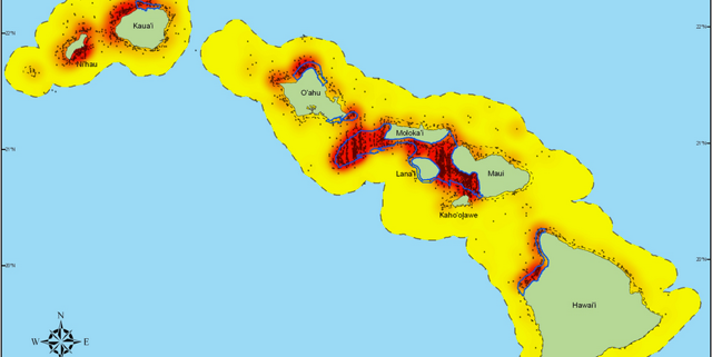
The sanctuary has experienced success through research, education and, more specifically, through the use of GIS. Often considered a mapping tool, GIS offers a way to “view, query, interpret, and visualize various sorts of spatial data to reveal geographic relationships, patterns, and trends (NOAA).” Moreover, “maps, charts, and analytical reports can be derived from the data stored in a GIS as a means of documenting and explaining spatial patterns and relationships to assist in planning and decision-making processes (NOAA).” As seen in GIS-generated maps, the density of marine life, specifically humpback whales, is significantly higher in and around the sanctuary, compared to the density outside the sanctuary boundary. Hawaii has already developed an elaborate network of Marine Life Conservation Districts; coupled with GIS programming, the two are useful in evaluating critical habitats and relevant ecosystem processes to establish adequate boundaries for marine protected areas.

With data courtesy of Joseph R. Mobley, this GIS-generated map depicts the Hawaiian Humpback Whale density in and surrounding the Hawaiian Islands Humpback Whale National Marine Sanctuary (Mobley, Joseph R. “Humpback Whale Surface Sightings and Estimated Surface Density.” NOAA, 14 Jan. 2013)
As is evident in Hawaii, using mapping tools can contribute toward effective means of conservation. GIS and related software is being used more frequently to map oceanic habitats, as well as things like water quality, species distribution, population, pollution, fishing grounds, and other factors that influence marine life. Going forward into the future, the selection and establishment of marine protected areas will depend on the connectivity of targeted species, and GIS will contribute to making these decisions.
References:
“National Marine Protected Areas Center: GIS for Marine Protected Areas.” National Marine Protected Areas Center. NOAA, 28 June 2013.
“National Marine Protected Areas Center: The Hawaii Coastal Use Mapping Project.” National Marine Protected Areas Center. NOAA, 22 Oct. 2013.
“Humpback Whale (Megaptera Novaeangliae).” NOAA Fisheries Office of Protected Resources. NOAA, 5 Sept. 2013. Web. 03 Dec. 2013.
“GIS for Ocean Conservation.” Esri, Dec. 2007.


Leave a Reply
Want to join the discussion?Feel free to contribute!